| The Ptarmigan Traverse - Then and Now |
| Story by Lowell Skoog | Photos by Tom Miller - reproduced with permission |
|
The
Ptarmigan Traverse is the oldest and most famous high route in
the Northwest. The first crossing of this route in July 1938 by
four members of the Ptarmigan Climbing Club has become a standard
in Northwest mountaineering folklore. Over thirteen days, Calder
Bressler, Bill Cox, Ray Clough and Tom Myers pioneered the entire
crest route from Dome Peak to Cascade Pass and made many first
ascents. Yet the Ptarmigans, soon scattered by World War II,
never published their story. For many years, how they made their
journey and what they saw remained a mystery.
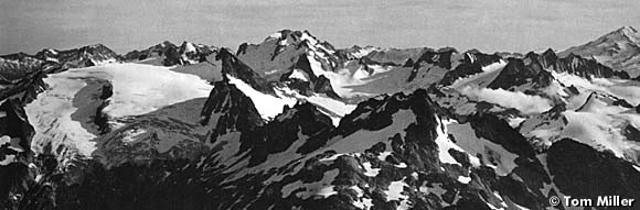
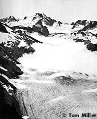
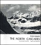
In 1953 five climbers, Dale Cole, Bob Grant, Mike Hane, Erick Karlsson and Tom Miller, calling themselves the "What is South of Cascade Pass Anyway?" Expedition, set aside two weeks in September to explore this "mysterious, legendary maze." They traversed from Cascade Pass to Dome Peak, reversing the direction taken by the Ptarmigans, and recorded their journey in The Mountaineer in 1953. More significantly, Tom Miller returned with dozens of fine black and white photographs of the glaciers, lakes, and crags along the route. Ten years later, as conservationists fought for a North Cascades National Park, Miller lent his pictures from the Ptarmigan Traverse and several other trips to The Mountaineers. A book of his photographs, The North Cascades, was published in 1964. The book was a success. Not only did it help establish the National Park in 1968, it inspired a generation of Northwest climbers. It was the first picture book to showcase the peaks and glaciers of the North Cascades from a climber's perspective. While the Ptarmigans in 1938 made their traverse a campfire legend, the 1953 party and The North Cascades made it a classic. Printed only once, the book soon became hard to find. Young climbers who started exploring the North Cascades in the 1970s, before modern guidebooks were available, jealously thumbed through the book in their friends' collections or on library shelves.
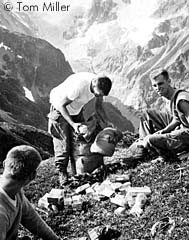
Photographer James Martin, who published his own collection of pictures in the 1999 book North Cascades Crest (Sasquatch Books) wrote: "I remembered a shot from Cache Col ... a black-and-white photo of three crew-cut young men sorting food in the morning sun... From the cloistered gloom of my high school library, these young men seemed like gods, American versions of legendary alpinists Bonatti and Buhl. I prayed I would someday have the fortitude to follow in their footsteps." My own experience was similar. One of my climbing mentors showed me the book in the mid-1970s and for years I hoped to find a copy of my own. Two friends gave my wife and me a copy as a wedding present and we have cherished it ever since. In the years since I first saw the book, I've crossed the Ptarmigan Traverse several times on foot and by ski. The summer of 2003 was the driest in over a century in the Northwest, and one of the warmest as well. From the Alps, reports of record heat and disintegrating glaciers brought worldwide attention to the effects of global warming. Reading these stories, I recalled that 2003 was the fiftieth anniversary of the 1953 Ptarmigan Traverse by Tom Miller and his friends. I nurtured a desire to retrace the route and see what changes had occurred in fifty years, especially to the glaciers. Tom Miller graciously provided me with xerox copies of the pictures he took on his trip, including photos never published. Phil Fortier and Matt Peters, two avid photographers, agreed to join me. Finally Tom Miller's son Brian joined us at the last moment. Brian is a strong and active climber, but had never done the traverse before. Together, we made a very compatible party.
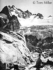
We planned our trip over Labor Day weekend. The 1953 party also started on Labor Day, packing 150 pounds of food to sustain the five men for fifteen days. Dropped off at the end of the Cascade River road, they would have to find their way home by hitch-hiking. They hiked to Cascade Pass the first day, then continued over Cache Col to Kool-Aid Lake on day two and climbed Hurry-up Peak. We carried lightweight gear such as Gore-tex tents, aluminum crampons and freeze-dried food and packed for only five days. Thanks to our lighter loads, we reached Kool-Aid Lake and Hurry-up Peak in a single day. I doubt that our faster pace reflected any weakness in Tom Miller's group. Had our places been exchanged, they probably would have hiked circles around us. On our second day we traversed from Kool-Aid Lake to Red Ledge, where we encountered a snowpatch that required donning crampons. This began a ritual repeated many times during the trip--stopping to put on crampons to cross hard, late-season snow, often just a few hundred feet wide. We roped up on the Middle Cascade Glacier and climbed to Spider-Formidable Col, where we had a fine view of Sentinel Peak and Le Conte Glacier.
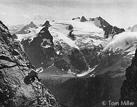
It seemed fitting that Brian Miller should pose for my camera on the rocks of Spider Col as I tried to recreate one of my favorite pictures from his father's book. I found it impossible to frame the background scenery through the col exactly as in the 1953 photo, probably because the glacier where I was standing had become thinner. A step-ladder would have been necessary to duplicate the shot. Tom Miller's party camped just south of the col and climbed Spider Mountain and Mount Formidable the next day. We chose to leave the rotten rock of Spider for another day, and climbed Mount Formidable enroute to a camp at Yang Yang Lakes, which were named by the 1953 group. Again we compressed two of our predecessors' travel days into one. At Yang Yang Lakes we met another party of two, friends we knew from Seattle, who had hiked all the way from the Cascade River road that day without climbing any peaks. This was the surest sign of change since 1953. Historically, the first three parties to cross the traverse spanned almost twenty years. Today, more than twenty parties may make the trip in a single summer. Meadows along the route are crossed by a well defined path. Campsites are also well established, especially near the lakes. Fortunately, the campsites are clean and travellers have made an effort to tread lightly upon the land.
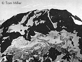
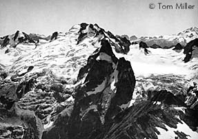
The next morning we climbed through bluffs to the ridgeline below Le Conte Mountain, which offered a panorama worthy of a scene in The Sound of Music. We dropped our backpacks and scrambled up Le Conte. Here we saw the most dramatic change from 1953. The South Cascade Glacier, which occupies a hanging valley below the peak, has shrunken to a shadow of its former self. Our view of the scene was marred by smoke from forest fires burning at both ends of the Ptarmigan Traverse. My photos from Le Conte were disappointing due to the smoke. A few years later Tim Ragan sent me a photo taken from the same location in 2005 in perfect weather. His photo provides a much better comparison against Tom Miller's 1953 shot. The only advantage the 1953 party had over the original Ptarmigans was the knowledge that a route existed between Cascade Pass and Dome peak, if they could find it. Immediately south of Le Conte Mountain, they crossed the divide hoping for an easy descent to the South Cascade Glacier. Instead they spent several tense hours "on the steep till of an old lateral moraine, cutting steps in hard-baked clay, clinging to boulders and pebbles imbedded more or less firmly in the slope, and contemplating the result of a fall, which would surely result in a dirty death by abrasion." As compensation, when they reached the head of the glacier they discovered three beautiful lakes to the south, which they named White Rock Lakes. The next day they climbed back up to the glacier with light packs and climbed Sentinel and Old Guard Peaks.
With the benefit of guidebooks and the accumulated knowledge of a generation of climbers, we avoided the unpleasant descent to the South Cascade Glacier, staying east of the crest until Le Conte Glacier and then crossing to the South Cascade next to Sentinel Peak. We dropped our packs and climbed Sentinel as we rounded its west flank, then continued to White Rock Lakes for our third camp. From White Rock Lakes the 1953 party traversed to the west portion of Dana Glacier, climbed Spire Point, then continued to a camp below the SW summit of Dome Peak. They spent two days climbing Dome and several unclimbed peaks nearby. With less time available we chose Dome Peak as our last summit and debated whether to reach it from the lakes by a direct route through Dana-Dome Col or the conventional route past Spire Point and across the west flank from Itswoot Ridge. We settled on the latter route, both to shorten our final day and to avoid hard ice between the two Dana Glacier segments, which could be unpleasant with aluminum crampons.
We crossed Spire Col to Itswoot Ridge and set up camp on the ridge around noon. Then we scrambled with light packs across the slopes west of Dome Peak and up the Dome Glacier to the summit. From the top we could see fires burning on a shoulder above Sulphur Creek and sending smoke over Sinister Peak and the Chickamin Glacier. To the north, another fire on the slopes of Johannesburg Mountain pumped smoke into the sky until it condensed in a billowing cloud of white vapor and sent a smokey banner across the Cascades to eastern Washington. After returning to our camp on Itswoot Ridge, we cooked supper and watched the sunset bathe Dome and Glacier Peaks in golden light. I'd brought a story about the original Ptarmigans and read it to the group by headlamp as the alpenglow faded to starlight. Our fifth and final day required simply a long walk down the Bachelor and Downey Creek trails to our car. In 1953, the end of the traverse was not so easy. No trail existed in Bachelor Creek in those days, so Cole and Hane, who had to leave early, bushwacked out Sulphur Creek to the Suiattle River, the shortest route to civilization. Grant, Karlsson and Miller packed east over Dome Peak to the Chickamin Glacier and down to Blue Lake below Agnes Peak. After a day of rain, they descended Icy Creek and the West Fork of Agnes Creek to the Stehekin River. Karlsson advised future parties against this route, but offered: "If anyone is interested in obtaining information on hanging valleys, waterfalls, slide alder, whip willow, and the latest beaver dam projects on the West Fork, we will be glad to inform him on such matters." Despite this struggle, Miller, Karlsson and friends soon forgot about the hardships and savored the rewards of the traverse. "There are not enough adjectives in the English language to describe the wonderful country we saw," wrote Karlsson. "We most heartily invite you to make a trip into this area." In the years since their historic trip, hundreds of climbers have followed in their footsteps. Let us hope that in another fifty years the Ptarmigan Traverse will not be too much different than it was in 1953.
|
 Sources
The Alpenglow Gallery