| Mission | Submission Guidelines | Editorial Team |
| Issue 4 | Archive |

| There and Back Again | ||
| Alone on the Ptarmigan Traverse | ||
| by Jason Hummel |
|
|
||||||||||||
|
|||||||||||||
|
|||||||||||||
|
|||||||||||||
While the Ptarmigan Traverse is a wonderful hike, the peaks along the way are a large part of why people go in the first place. Reflecting on my plans (which didn’t include any summits), I fancied myself climbing one or two of them somehow, but that wasn’t practical. I had other challenges to surmount and right then I wasn’t entirely sure how I was going to handle those. Better to be reasonable, but was going alone reasonable? That scared me more than anything else, but it’s also what allowed for me to set off on such an interesting journey in the first place. Earlier that day I had made several stops to hide my road and mountain bikes and my kayak which, alternatively, would take me back to my car some 67 miles of river and road, all after the 30-40 miles of foot-travel along the Traverse. Normally you’d have two cars, but unfortunately my clone was working (my twin brother). What I had was the few hours of that day remaining and another three days to finish the whole affair and return to my car.
To begin, I had a choice to sleep in my car or on heather-carpeted slopes above. Not willing to ignore my newfound freedom, I left at 8 p.m., soon happening upon two headlamp-illuminated hikers returning from a late climb of Sahale. Pulling up to chat as they were getting water, they pleasantly told me of their climb and warned of a local bear in the area. Their words of caution were ignored as I continued up into the fog. With the last people I saw that night behind me, I found myself alone. Being away from the comfort of home is a wild feeling, and can be addicting and demoralizing at the same time. You feel satisfied when you complete what you set out to do while, on the other hand, you can become insanely terrified at times when you feel you have no control, and within the eerie aisle of this trail I felt that. With tree branches slapping me in the face, fog slithering down the slopes, and the night encasing me within my headlamp’s brightened sphere, I couldn’t help but allow maddening sounds to fracture my thoughts. I imagined these sounds coming from mischievous little devils whose job it was to magnify each and every sound tenfold. At breakneck speeds, my efforts to escape the fog pushed me forward and my attention was behind rather than ahead; in an abrupt way, that was about to change. Materializing from the night, the bear’s glinted-yellow eyes met mine, now stricken with fear, and the ground shook. I felt like I should find a rock or tree to crawl under, but I didn’t. Instead, I stubbornly backed down the trail and waited, soon releasing the breath I’d been holding the entire time. I could hear him further down the slope. When all was clear I forged ahead, having avoided being some beast’s supper, up the trail even faster than before. Not long after, the fog fell away and the heavens opened up. Mountains silhouetted the darkened skies and I settled down for the night, satisfied. Overall I was glad I had continued on rather than spending the night at the car, because going to sleep below Cache Col with the mixture of stars and mountains above couldn’t be beat. I only hoped the days ahead would be easier, but no less adventuresome. DAY TWO: Cache Glacier to the South Cascade Glacier
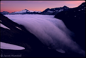
Getting into the North Cascades in summer is much different than in winter or early spring. I usually prefer snow-blanketed heights in June, but not that morning when I arrived at Kool-Aid Lake. Seized as I was by those shadows walking ridges and fog and clouds still boiling and frothing in the valleys, I couldn’t help but want to linger. With my early start I was soon making up lost time, but I would lose it again on Red Ledge, which is the name for a short climb around a steep and narrow ridge called Art’s Knoll. I searched high and low for the correct route, but ended up settling for another way. It was on red ledges, albeit not the correct ones. I didn’t put boots on until I came to Spider Pass. The Middle Cascade Glacier is fairly flat, but seasonal snow drops steeply off the far side of the pass. Tom Miller has a photo in the book, The North Cascades, that was taken here, and I hoped to imitate it. I hardly managed to outrace my camera’s timer. Le Conte Peak’s rock-thorned summit, the milk-toned waters of Le Conte Lakes, and the pasty-white Le Conte Glacier remained to satisfy me. At Yang Yang Lakes I had breakfast on the sandy shore farthest from two people who were resting in their camp between the lakes. Eventually sauntering over, I bothered them for directions to Le Conte Glacier, the route not obvious to me. Very helpfully they pointed the way. I bade farewell and soon worked up a steep gully toward a higher bench. The LeConte Glacier was the most challenging glacier of the trip and excellent conditions made my work easier. By the time I neared the glacier’s end, the day was cooling and my shadow stretched across the snowfield. Knowing I wouldn’t get much further, I raced over a rock-strewn pass to the sight of the South Cascade Glacier, reminding me of the equally fantastic Blue Glacier on Mount Olympus. I reached 6-mile camp at the confluence of Bachelor and Downey Creeks, as far as I thought I would get. After dinner darkness brought out the stars which could hardly keep me company through the thick canopy of forest. Instead the resident mouse unfettered by my presence munched anything he could find until I packed everything away, everything except my fingers which were all that remained peeking out of my sleeping bag. A sharp pain raised me not long after I closed my eyes. The CARNIVOROUS bastard only managed to get one chunk of skin before I decided to finish my hike off in the dark. Never had I had a mouse do that. I reached the parking lot later that night and started a fire. With my bed set and the fire flickering, I saw in the shadows another mouse. Any fingers were kept in my bivi and my pocket rocket stove and fork close at hand. My rest lasted a few hours. I had a big day ahead, and I was too full of anticipation to sleep long. Near the parking lot I headed into the jungle where I switched my overnight gear for a kayak and paddle
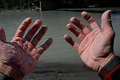
The change from high alpine to cold glacier runoff was exhilarating. This section of river had been pounded by huge floods that filled most rapids and corners with logs and debris. For the most part I boat-scouted and had to portage a few log jams that I couldn’t squeeze through. In contrast to the upper section, the lower portions featured a canopy of trees, filtering sun dancing on waves, and clean rapids. Along the way, I met a group of rafters who were spending a few days on the water. One guy told me how they used to float the Cascade River in drift boats which must’ve been exciting. Fun and exciting for me were the miles and miles of wave trains and boulder gardens. The splashes were always refreshing. I rounded hills, rushed by tributaries, sped through rapids, crashed over rocks to finally meet the Sauk River exhausted and tried. My hands felt like lead weights. But with no time to rest; I exchanged kayak for hidden road bike and hit the highway. Only a few cars passed me by as I cycled toward the Cascade River Road; my head down, I grinded the miles away and found myself making great time. That is until I started clicking the gears down and down until I could go no lower. My legs were now jello, so anymore punishment was too much. Reaching the end of the pavement, where the mountain bike was hidden, was a short-lived relief. I knew the mountain bike portion would be worse and it was. I traded bikes, drank a little water (as I had only a liter) and rode out. Every creek tempted me for miles. When the road steepened, I’d walk for short distances, but I knew more riding was needed. I had no time to walk the entire way. Finally reaching mile 21, I stashed my bike in the trees next to the gate and walked. The sky was darkening by then, and every car that passed was another temptation. I was on a mission, though, and to give up this close would be a shame. I was determined to spend the night with my camelback as a pillow before giving up. At 9:30 p.m., 74 hrs after I began, I reached my car. Another mile would’ve been too much. I was done and better than happy that my solo venture had been a success. I will never forget the experience. The solo journey changed me in more ways than I can explain; seeing so much country in such a short amount of time was very satisfying. Traveling from the high country to the low country, walking high ridges and glaciers, kayaking rivers and riding the highways completed a circle all of the way back to the beginning; a round trip journey completed in fine style. |
|
|
|||||||||||||||||||||||||||||||
| ©2007 Northwest Mountaineering Journal | |||||||||||||||||||||||||||||||||
| Site design by Steve Firebaugh | |||||||||||||||||||||||||||||||||
;)
;)
;)