home
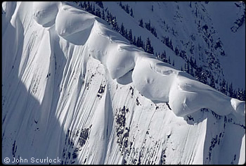
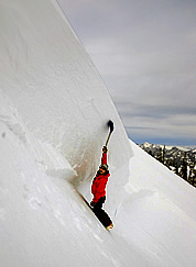
Dangerous snow cornices. Photo © John Scurlock.
 
  Deadly Season of Avalanches  
  by Garth Ferber – Northwest Weather and Avalanche Center  


T

he winter season of 2007–2008 had the most avalanche fatalities seen in Washington in modern times, discounting the icefall accident on Mount Rainier in June 1981. What happened? First let’s look at this winter’s weather patterns and snowpack growth.

Winter Weather Summary
The La Nina winter started rapidly during a short but major storm and avalanche cycle in early December. On December 3, the last storm in this cycle was fed by moisture from the remnants of Typhoons Hagibis and Mitag. Snow measurement sites near the Washington Cascade crest received about three feet of snow on December 2 and 3. This came with a major warming trend which changed the heavy snow precipitation to heavy rain on December 3. The increasing wet snow and rain generally accumulated on old snow crust layers from November. This cycle is indicated in the precipitation chart by the spike in snow depths in early December. Five avalanche deaths in two accidents occurred in the Cascades during this time.

Bram Thrift examines the crown wall of a slab avalanche at Alpental on January 1, 2008.  The avalanche occurred the previous day.  Photo © David Kratsch.
Bram Thrift examines the crown wall of a slab avalanche at Alpental on January 1, 2008. The avalanche occurred the previous day. Photo © David Kratsch. Enlarge

The next storm cycle extended from mid December to mid January. Hurricane Ridge in the Olympics and locations near and west of the Cascade crest accumulated 17 to 24 feet of snow during this one-month period. Many sites had several days, sometimes consecutive days, of a foot or more of snowfall. Snowfall was especially heavy at Mount Hood. Three more avalanche accidents, on December 18, New Years Day, and January 4, claimed the lives of four more people.

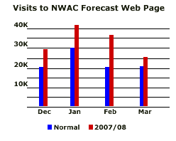
Another storm cycle extended from the last few days of January through the first half of February. Sites near and west of the Cascade crest picked up 10-15 feet of snowfall during this two week period. All three major Cascade pass highways (Stevens, Snoqualmie, White Passes) had extended simultaneous closures during this period. The most snowfall occurred at Paradise and White Pass which averaged over a foot a day for two weeks! (I distinctly remember the tired voices each morning when talking to snow safety crews who had to battle this relentless snowfall.) The public was now paying more attention to the avalanche forecasts (see chart in sidebar) which may partly explain why no more avalanche deaths occurred during this time. But access to the Cascades was also restricted due to closed roads.

The Northwest experienced an unusually cold spring with snow continuing to accumulate in April in the Olympics and Cascades. This led to record total snow depths in the south Cascades at White Pass and Mount Hood Meadows by May 1, leading to abnormal late season avalanche activity.

Accident Summaries

The following summaries provide short descriptions of the fatal accidents that occurred in the Cascades in the winter of 2007-08. Also provided are weather charts enabling readers to reach conclusions on their own. More complete accident reports are available on the Northwest Weather and Avalanche Center web site (www.nwac.us) and on the Westwide Avalanche Network web site (www.avalanche.org). I found writing about these accidents a sobering task.

Not included in the summaries and statistics, a back country skier went missing on April 27 while skiing on the west side of Mount Baker, likely due to an avalanche or crevasse fall. The skier has not been found.

Union Creek, December 2, 2007

Kevin Carter, 26, Devlin Williams, 29, and Phillip Hollins, 41 were reported last seen descending into Union Creek Basin near Crystal Mountain ski area on Saturday, December 1, traveling via snowshoes and snowboards. By 11 a.m. on Sunday, 27 inches of new snow had fallen in the previous 18-hour period, accompanied by high winds, warming temperatures, and poor visibility. By Sunday afternoon rain began to fall up to an elevation of 7000ft and the avalanche danger was extreme. After the snowboarders were reported missing, Pierce County Sheriffs began a search and rescue operation on Monday, December 3. Initial response was slow because of strain on rescue crews due to flooding and other weather related emergencies throughout western Washington. Crystal Mountain ski area had to shut down because most of the shallow snowpack either avalanched or was washed away, and power and phone service were out for a time.

When the weather began to clear on Tuesday, searchers confirmed that nearly all of the steep slopes in the area had released large climax avalanches running full path distances. Air and ground searches continued until Saturday, December 8, when a decision was made to suspend search operations until spring. On June 21, 2008, after periodic search efforts by members of the Crystal Mountain ski patrol and friends of the victims, the bodies of the snowboarders were found by a group of volunteers organized through the Turns-all-year backcounty skiers web site. The victims were discovered at 5420ft near the bottom of Union Creek Basin, buried in their sleeping bags and bivi sacks. Apparently they had hunkered down during the storm and were caught by an avalanche sweeping down from open slopes through the stand of 30 to 50-year-old cedars and silver firs where they had camped. (This information is from a report written by Paul Baugher, Chris Morin and Mark Moore after the recovery.)

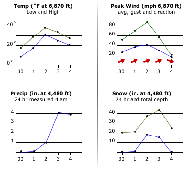
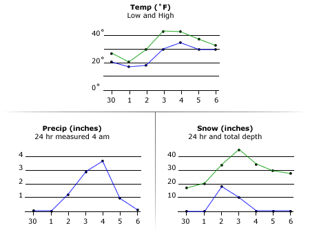
Weather charts are derived from data from NWAC weather stations at the Crystal Mountain ski area from November 30 to December 4.


weather charts


Source Lake, December 2, 2007

Much of the following information is from an accident report written by Rob Gibson of the Alpental ski area.

A party of three snow campers (husband and wife Mark and Stacia Thompson, 38 and 33 respectively, and friend Craig Stanton, 38) hiked to Snow Lake on Saturday, December 1. Late the next morning, the party broke camp and ascended back to the ridge between Snow Lake and Source Lake. From the accident report: “The wind was strong at their backs and the ridgeline was scoured to the old snow and dirt. It was obvious that the steep slope before them was in the lee and significantly loaded but the very strong wind made staying on the more exposed ridgeline uncomfortable and they began to descend onto the loaded slope.  The survivor was the most experienced of the group and was in the lead, hoping to trigger a sluff ahead of him and relieve some of the slope’s avalanche potential. He stated that they began to descend in single file and reports hearing an exclamation from behind by one or both of the other party members just prior to being hit from behind by a wave of snow and carried down slope rapidly.” The survivor (Mark Thompson) was partly or completely buried with a broken leg but able to extricate himself. Rescuers found him with a broken leg in a partly erected tent on Tuesday morning, December 4. The two fatally buried victims were found soon after using a rescue dog. Rob Gibson later commented to me that his impression was that the slab released and stayed in new snow layers.

This weather and avalanche cycle was the same cycle that caused the Union Creek accident. Again the warming trend and change to rain are obvious. The accompanying charts are derived from the NWAC Alpental 3,120ft base station data. Alpental upper mountain data is not available.


weather charts


Edith Creek, December 18, 2007

Troy Metcalf (age unknown) and Kirk Reiser (22) climbed partway to Camp Muir on Tuesday, December 18, and turned around due to bad weather conditions. They apparently descended from the vicinity of Pan Point toward Edith Creek Basin. Reiser apparently triggered the avalanche that carried him into Edith Creek Basin. A rescuer commented to me that Rieser’s body was in a moat between perennial snow and a cliff. The news report described the avalanche as 40 yards wide by 200 yards long. Metcalf searched for several hours before having to return to Paradise for help. Searchers using metal detectors and search dogs located the deeply buried victim the following day. (This information is mainly from a news article in the Seattle Times. Edith Creek weather data in seperate tab is from NWAC weather stations at Paradise. )

Edith Creek Weather


Excelsior Pass, January 1, 2008

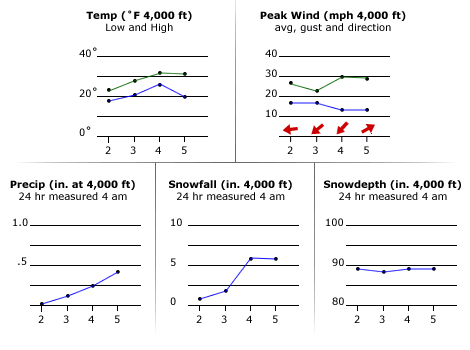
A group of five snowmobilers was high marking in the vicinity of Excelsior Pass on New Years Day. At about 1 p.m., a slab was triggered that was about 5-7 feet deep by about 100 yards wide. The avalanche caught all five, but two were able to escape and one was only partly buried. The first victim was found by transceiver and excavated by the other three after about two hours. The second victim was not wearing a transceiver and was found by probes and excavated the next day by rescuers. (This information is from a rescue report authored by Mark Moore and provided by Bellingham Mountain Rescue.)

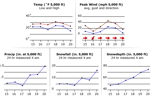
The Cascades had a warm spell on December 22-24 which formed snow crusts in many areas. About a foot of new snow fell nearly every other day at the Mount Baker ski area in the second half December. At the ski area, January 1 was also warmer and windier, which may have contributed to the formation of a wind slab.

The weather charts are derived from NWAC weather station data at the Mount Baker ski area. The wind instruments are unheated, so rime build-up can affect the data. Rime prevented the wind instruments from recording for most of the day on December 31.


Excelsior weather

snowfall and snow depth

Looking up from accident scene.


Lake 22, January 4, 2008

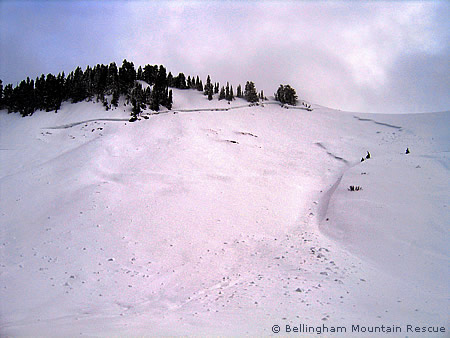
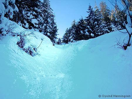
A group of one adult and six youths were descending the Lake 22 trail on foot during the midday or afternoon of January 4. The group was crossing a NNE facing gully at about 2200ft when a natural avalanche from above hit four of the group, partly burying one youth and completely burying three other youths. The partly buried youth was able to self-extricate and two of the others were quickly found by probing with ski poles. The other buried girl could not be found. The group returned to a ranger station and called 911 at about 4:45 p.m. Everett Mountain Rescue responded and at about 9:30 p.m. found the victim by probing, located 200 to 300 feet below where the group was struck on the trail.

The gully in which the group was struck apparently extends several hundred feet above the trail (see photo of scene). Everett Mountain Rescue reported blocks of snow of about 1.5 meters thick above the trail which may have been pieces of a cornice. The group also reported that they had turned around and were descending, in part due to increasing rain. (This information comes from a report written by Mark Moore, based on information from Everett Mountain Rescue.)

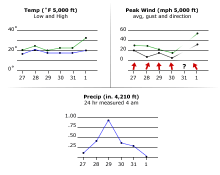
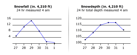
Of the available weather monitoring sites, data from NWAC weather stations at Stevens Pass seemed most relevant. 140 inches of snowfall occurred at the Stevens Pass NWAC weather site in the second half of December and the first four days of January, offering a lot of snow or cornice buildups available for an incident. The temperature and wind direction change at Stevens Pass indicated a warming trend.


Lake 22 weather charts

View up chute from accident scene.


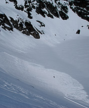
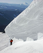
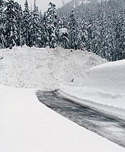
Skier triggered slab avalanche in the Enchantment Lakes, April 24, 2008. Skier can be seen standing in the debris. Photo © Matt Peters.   Asa Mueller lends scale to a natural avalanche crown in White River Canyon, Mt. Hood, February 8, 2008. Photo © Tyghe Stoyanoff.   Thirty feet of debris from a control avalanche across the highway at Tunnel Creek near Stevens Pass, February 9, 2008. Photo © Mike Stanford.

Skier triggered slab avalanche in the Enchantment Lakes, April 24, 2008. Skier can be seen standing in the debris. Photo © Matt Peters. Enlarge

  Asa Mueller lends scale to a natural avalanche crown in White River Canyon, Mt. Hood, February 8, 2008. Photo © Tighe Stoyanoff. Enlarge  

Thirty feet of debris from a control avalanche across the highway at Tunnel Creek near Stevens Pass, February 9, 2008. Photo © Mike Stanford. Enlarge


Reading the Hazards
Washington’s 2007-08 winter season was unusual in that:
La Nina winter contributed heavy snowfall in the Cascades.
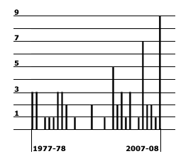
Nine fatalities from avalanches compared to annual average of two.
A major widespread avalanche cycle occurred early in the season.
Heavy Snow Winter

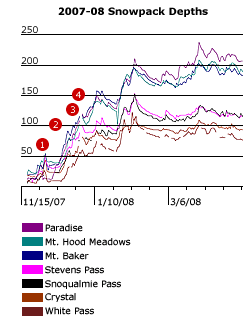
The chart below illustrates the snowpack growth at various locations in Washington and Oregon. The dates of the fatal accidents are indicated as follows:
1) Union Creek and Source Lake
2) Edith Creek
3) Excelsior Pass
4) Lake 22

Snowdepth is in inches, timeline is marked off in two-week intervals.

Avalanche snowpack chart

Fatalities Over the Years
The following chart shows annual Washington and Oregon avalanche fatalities for the past 30 years. Each bar represents the fatalities in a single winter season. Years without a bar had no fatalities. Average number of fatalities is about two per year. Data excludes the June 11, 1981, Mt Rainier icefall accident.
Avalanche fatalities chart
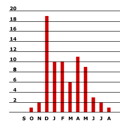
The chart below records the total avalanche fatalities each month from the 1974-75 season to the 2007-08 season, ordered from September to August. December is the most deadly month with 19 deaths.

Avalanche fatalities chart

NWAC Avalanche Warnings
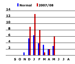
The number of warnings issued by NWAC was quite a bit above average from December 2007 to February 2008 and again in May 2008. The following chart compares the warnings issued in 2007-08 compared to the monthly average.

avalanche fatalities chart

NWAC Website Visits

Visitation statistics for the NWAC avalanche forecast web page (below) suggest that people do not pay as much attention to avalanche forecasts early in the winter as in mid winter. Perhaps the major avalanche cycle in early December 2007, combined with the fact that recreationists were less attuned to avalanche forecasts at that time, were factors in the fatalities this season.

NWAC Visits