|
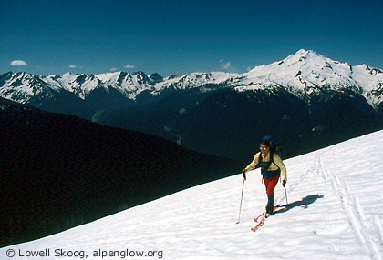
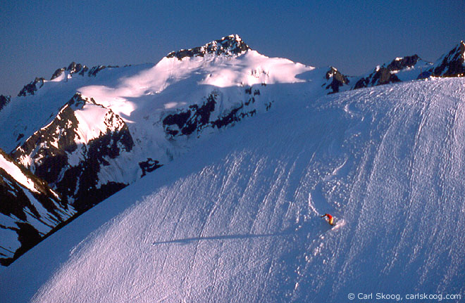
| An evening ski run at High Pass, camp four on the Suiattle High Route, June 1989. Clark Mountain is in the distance. (Map, 900kb) |
|
During the late 1980s and early 1990s, I became intrigued by the idea of skiing the North Cascade crest in a continuous push. I was inspired by pioneers like Orland Bartholomew, who skied from Mount Whitney to Yosemite in the Sierra Nevada during the winter of 1928-29. My interest centered on the mountains between the North Cascades Highway and Glacier Peak, which include the southern half of North Cascades National Park and the heart of the Glacier Peak Wilderness Area. I called this 100-mile route "The American Alps Traverse."
I had traversed the northern two-thirds of this route in stages. In 1983, I skied from Snowfield Peak to Eldorado Peak ("The Isolation Traverse"), and in 1987 I did a comparable trip from Rainy Pass to Eldorado ("The Thunder High Route"). The Ptarmigan Traverse, which I skied in 1982, formed the central third of the grand route. What remained was the long, curving crest from Dome Peak to Glacier Peak. My brother Carl was interested in this project, and we mapped out a route that would cover most of the southern third of the crest. We wanted to start close to Dome Peak, but we didn't want to retrace the Downey and Bachelor Creek trails to get there. We decided on the Bath Lakes High Route as our approach to the high country. This route begins at Sulphur Mountain above the Suiattle River and leads east to Totem Pass and Canyon Lake. From there a trail, snow covered in spring, leads south to Image Lake on Miners Ridge. From Image Lake we would traverse to Lyman Lake, then ski high over Chiwawa and Fortress Mountains to Buck Creek Pass. We'd continue over High Pass to the Napeequa valley, then traverse west along the Dakobed Range to Glacier Peak, finally hiking out the White Chuck River valley. Since the route circled the headwaters of the Suiattle River, we called it "The Suiattle High Route" (see map, 900kb). The trip was a long one, and we planned a full week to complete it. During the second week of June, 1989, we took advantage of a good weather forecast and set out for the mountains. We parked Carl's car at the end of the White Chuck River road then drove my car up the Suiattle River road to Sulphur Hot Springs. We grunted up the Sulphur Mountain trail carrying horrendous packs, made more so by the skis strapped onto them. Then we skied along a series of basins and ridges to a camp just east of the two largest Bath Lakes.
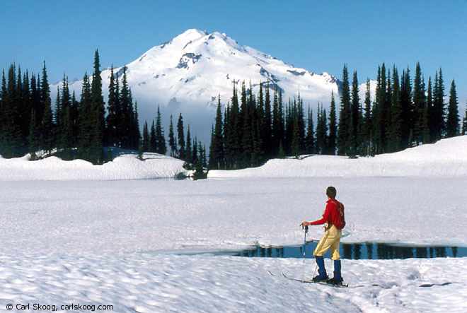
The first day was hard but the country was enjoyable. The second day, which took us past Canyon Lake to Miners Ridge, was just hard. To get to Canyon Lake we had to traverse south facing slopes that were too steep, too close to treeline, and too thinly covered by snow to offer good skiing. The route might have been better earlier in the spring, but I doubt it would ever be very good. In hindsight, I think it would be better to start the trip at Lyman Lake via Holden Village, but it would be logistically much more complicated. Our start on day two was delayed by fog, so we didn't reach our camp at Image Lake until nearly sundown. We camped in fog again and crossed our fingers for better weather. On the third day our efforts finally began to pay off. The fog lasted through the night, but after sunrise Carl looked out of the tent and saw Glacier Peak floating above the mists (see bottom photo). We were ecstatic. The view of Glacier Peak from Image Lake is one of the most famous in the North Cascades. Neither of us had seen it before, and we spent the morning like tourists strolling around the lake and taking pictures. Eventually we broke camp and skied along Miners Ridge to Suiattle Pass. Our route traversed the slopes of Plummer Mountain around 6400 feet, much higher than the hiking trail. Near Cloudy Pass we saw two telemarkers, undoubtedly from Holden, skiing on the shoulder of Cloudy Peak. They were the only other people we saw on the entire trip. Lyman Lake Basin was enchanting -- wide open and inviting -- very different from the terrain we struggled through the previous day. I could have lingered there happily, but we had more miles to cover. We skinned up the Lyman Glacier to the summit rocks of Chiwawa Mountain, then scrambled down talus on the other side to a skiable snow finger. The snow led us to the saddle between Chiwawa and Fortress Mountains, where we camped.
On the fourth day we climbed a snow gully and heather ramp to the south shoulder of Fortress Mountain. We carved turns down the broad southwest slope of Fortress to the Buck Creek Pass trail. We walked a section of snow-free trail, then skied around the east side of Liberty Cap and followed the crest to High Pass. High Pass was a wonderland, with a 360-degree view of high peaks and a garden-like mixture of heather, rock and snow. We pitched our tent on the highest knob with the best view (see top photo, above) and I skied various slopes for Carl's camera as the sun dipped toward the horizon. The next day we skied down the basin below High Pass and descended into the Napeequa Valley. The final, brushy slope leading to the valley bottom was devoid of snow. We portaged our skis along a trail that snaked through the brush like a tunnel. A short distance up the Napeequa drainage we were able to ski again. In the basin below the Butterfly Glacier we dropped our overnight packs and skinned to the top of Chalangin Peak. High clouds were increasing. Our NOAA weatheradio called for an increasing chance of rain. The summit of Glacier Peak was our chief goal for the end of the trip, so we bent our plans to improve our chances of getting up it. We traversed the north side of Tenpeak Mountain and, bypassing our intended campsite, continued up the Honeycomb Glacier to its saddle with the Suiattle Glacier. On the morning of the sixth day, with dark clouds and showers gathering around us, we began racing across the Suiattle Glacier toward the summit. By the time we reached the east shoulder of Disappointment Peak it was blowing hard and raining. We stopped in the lee of the peak to put on rain gear. The summit of Glacier Peak was socked-in and the clouds were descending, so we settled for Disappointment Peak as our consolation summit. Its name expressed our feelings about the weather, but not about the trip. We'd originally planned for a seventh day, but rather than camp out in the rain we skied down the Sitkum Glacier to Boulder Basin and hiked out the White Chuck River trail to our car. My obsession with skiing The American Alps Traverse was only intensified by this trip. In autumn 1990, I placed caches for a continuous ski traverse from the North Cascades Highway (starting either at Diablo Dam or Rainy Pass) to Glacier Peak. I cleared my calendar during the spring of 1991 and Carl and I made several attempts and false starts on the trip. But 1991 was one of those soul-crushing, soggy springs that sometimes happens in the Northwest. We were shut down. The gap between my ambitions and what I could actually accomplish was unbridgeable. I gradually realized that The American Alps Traverse, as I had originally conceived it, was not a good fit for me. Family commitments and typical Cascade weather made completing such a trip too stressful. I concluded that skiing the crest in segments, experiencing each segment in the best conditions I could manage, was better for me. Eventually, I expanded this project to include the entire Cascade Crest from Mount Baker to Mount Rainier, a distance three times as long as my original goal. In 2002, after I described my faded dream to my friend Matt Firth, he recruited Bob Nielsen to attempt The American Alps Traverse. Pushing hard, they skied from Diablo to Lyman Lake in eight days of June. From Lyman Lake, Nielsen returned home to Stehekin. Firth briefly considered continuing alone toward Glacier Peak, but the commitment of such a venture was too high, so he too ended his trip at Holden Village. They had made a worthy effort. --Lowell Skoog
|
||||||||||||||||||||||||||||
|
Previous | Next | Overview - Skiing the Cascade Crest | The Alpenglow Gallery |